These stunning satellite images look like abstract art – and they reveal much about our planet
- Written by Emily Finch, Research Affiliate, Monash University
Environmental scientists see flora, fauna and phenomena the rest of us rarely do. In this series, we’ve invited them to share their unique photos from the field.
There’s something to be said for a job that pays you to stroll over the Scottish Highlands, scoot around a Greek Island, or go on an expedition to Antarctica – all in the name of geoscience, the study of the Earth.
But during COVID travel restrictions, many geologists had to mine the collection of samples and data they already had. Other geologists used satellite and other images to make geological interpretations.
This field of geology is called remote sensing, which is the process of using, for instance, satellites or aeroplanes to observe the physical features of an area at a distance. It’s often easier to see how geology shapes our landscapes by taking this birds-eye view.
In terrific news for remote sensing geologists, armchair geology enthusiasts and lovers of stunning landscapes, the United States Geological Survey (USGS) has a vast collection of satellite images of the Earth’s surface, capturing breathtaking geological features from space.
Remote sensing geologists use many techniques which make features of interest more distinct. This enhances or alters colours, which you can see in a few of my picks of USGS’s eight most fascinating images. Here’s what they reveal about the planet.
Read more: 5 rocks any great Australian rock collection should have, and where to find them
Volcanoes from space
Volcanoes are usually pretty distinctive when you see them from the ground, whether it’s the iconic Mount Fuji, the lava fields of Iceland, or the hundreds of volcanoes that pockmark the fields of western Victoria in Australia.
From above, they can look a little different. In the first image below of Mount Elgon on the border of Uganda and Kenya, you can spot the “caldera” – a bowl-shaped depression in the centre of the volcano where the rock has collapsed after the magma chamber empties.
In the second image of New Zealand’s Mount Taranaki, you can spot the crater, which is also a depression, but forms when the volcano explodes and rocks are ejected.
The products of volcanoes may also be obvious in satellite images. You can see the lava flow from the Haruj volcano in Libya in the third image below. It is a black stain of basalt on the surrounding white and yellow sand, to envy even the finest Rorschach inkblots.
This field of lava is about 185 kilometres wide, a huge distance that’s possible because the chemical composition of the lava made it runny and able to flow a long distance from the eruption site.
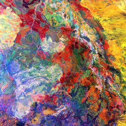
Some magma-related features have stumped geologists for years. Only by combining remote sensing with observations on the ground have they been able to solve these geological puzzles. The Richat Structure in Mauritania’s Maur Adrar Desert, shown below, is one such feature.
It looks like a meteorite impact crater or, perhaps, a bullseye for intergalactic visitors. But in recent years, researchers determined – after much debate – that it formed when a series of magmas from deep below the surface intruded into the existing sediments.
Some of these magmas formed concentric circles, known as ring dikes, which is the main feature we see in satellite imagery. These ring dike magmas never reached the surface and are only exposed now because the overlying rocks eroded away over time.
But other magmas in the series did make it to the surface to erupt as lava. You can see the small volcano formed by these surface eruptions on the USGS image where it appears as a white-grey smudge interrupting the southwestern part of the innermost ring dike.
Read more: Photos from the field: the stunning crystals revealing deep secrets about Australian volcanoes
When rocks collide
The landscapes of Iran’s Zagros Mountains and China’s Keping Shan thrust range have two major things in common.
First, they both look spectacular from above. Second, they were both formed at the bottom of oceans and were then uplifted and deformed by geological forces to form the ridges and valleys which dominate these two regions today.
Both mountain belts were created when land masses collided, and the pressure from these collisions caused the rocks to fold over themselves. In some places, the rocks broke apart completely.
These breaks, known as faults, brought up deeper, older rocks to sit on top of younger rocks. These faults form the layered ridges seen in the satellite image of Keping Shan.
Unlike Keping Shan, the ridges in the Zagros Mountains were formed when softer rocks, such as silt and mudstone, were eroded away over time. This erosion formed valleys beside the more resistant rocks of limestone and dolomite, which comprise the arch-shaped folded domes.
Unravelling rivers
Rivers make huge changes to our landscapes. Over many years they can find and exploit weaknesses in rocks to carve their way through any terrain. Rivers look and behave differently depending on factors such as flow rate, how much sediment they carry, and the gradient of the slope they’re on.
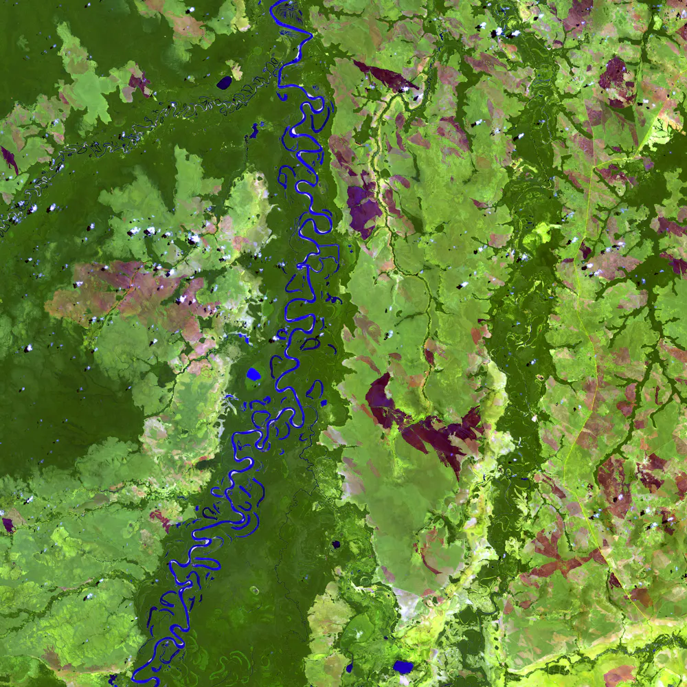
Rivers can consist of one narrow and winding stream (called a meandering river) such as the Beni River in Bolivia, or a wide channel made up of many branches braided together between bars of sediment (called a braided river), such as the portion of Brazil’s Rio Negro in the last image below.
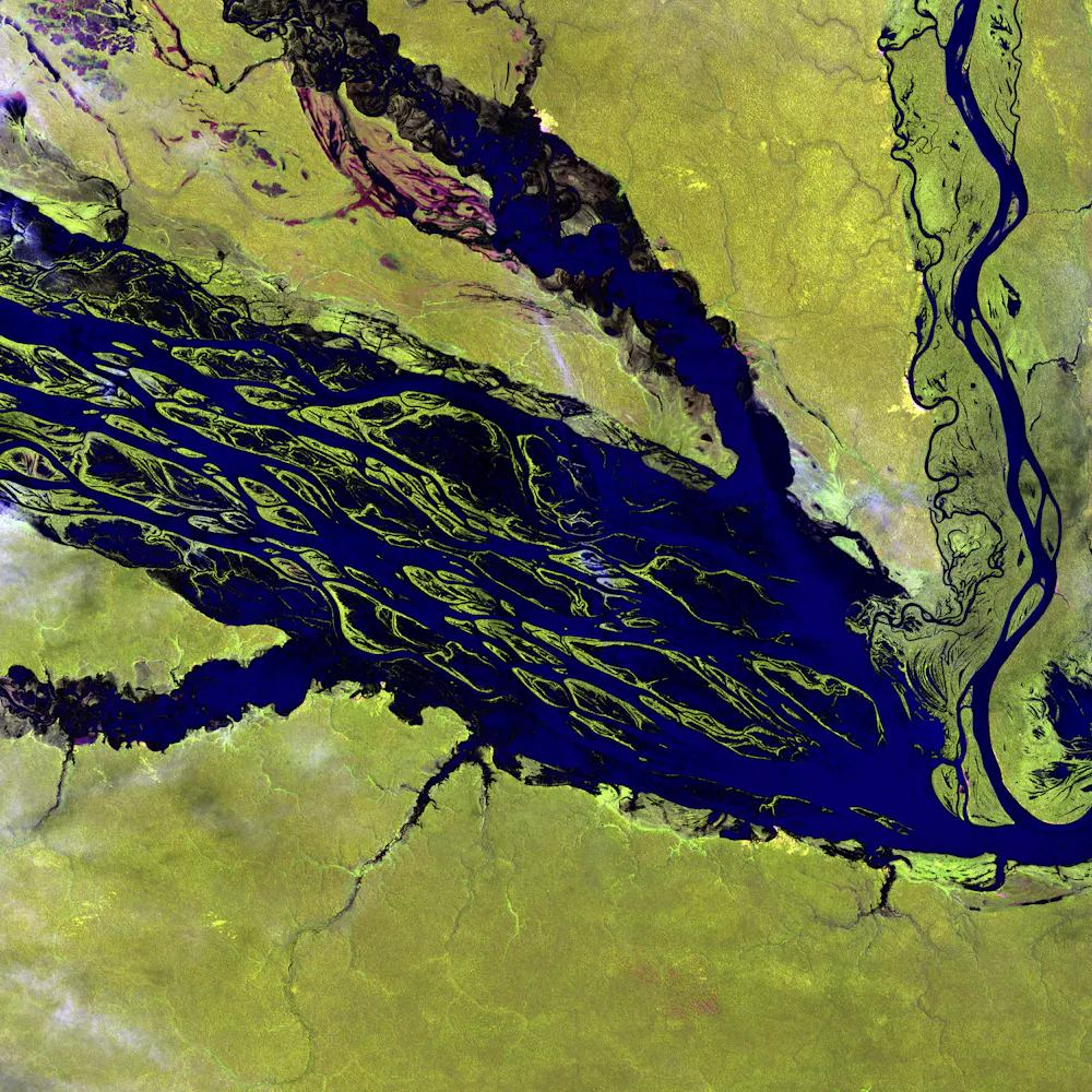 Rio Negro, Brazil.
United States Geological Survey/Unsplash, CC BY
Rio Negro, Brazil.
United States Geological Survey/Unsplash, CC BY
Looking at the meandering Beni River from above, you can see how the twists and turns of the river have evolved over time. The u-shaped lakes scattered along the edges of the river are called oxbow lakes.
These oxbow lakes are the former channel of the river which have since been cut off when the river eroded a new, more direct channel to follow. In Australia, oxbow lakes are also known as billabongs.
Unlike the slowly meandering Beni River, the wide channel of the Rio Negro is created by fast flows and the deposition of coarse sediment. These characteristics form the mosaic of small islands between the branching flow of water. The islands become submerged during Brazil’s wet season when the volume and flow of the water is higher.
Armed with this new knowledge, book a window seat next time you fly and see what geological wonders you can spy from above.
Read more: The dingo fence from space: satellite images show how these top predators alter the desert
Authors: Emily Finch, Research Affiliate, Monash University