
Satellite imaging is now vital for disaster management. But there are dangerous gaps in our systems
- Written by: Anna Marie Brennan, Senior Lecturer in Law, University of Waikato
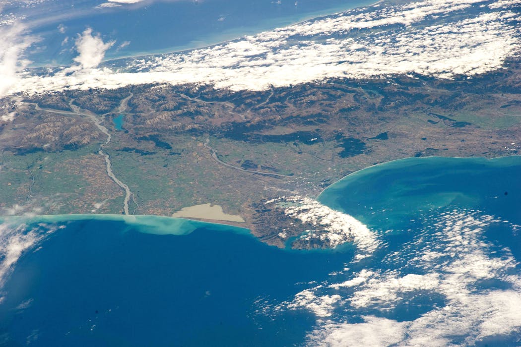
The extreme weather events and resulting destruction that have hit New Zealand this summer are not only signs of a changing climate. They also highlight the now indispensable role of remote sensing satellite technology.
Broadly, remote sensing involves gathering information about Earth from a distance – most often from satellites equipped with sensors that measure different forms of electromagnetic energy.
Operating across multiple wavelengths, these instruments can function at night and capture conditions over large areas in a single pass. Synthetic aperture radar (SAR) satellites detect ground movement and flood extent even during heavy rain and thick cloud.
Optical sensors capture detailed imagery showing building damage, blocked roads, sediment plumes and coastal change. Thermal sensors identify heat patterns and temperature anomalies that signal hotspots or stressed environments.
Together, these systems provide a reliable, real-time picture of ground conditions, especially when severe weather renders traditional monitoring impossible.
But despite this technological progress, the framework that controls access to satellite data is alarmingly fragile, leaving a disaster-prone country like New Zealand vulnerable.
Better emergency response and risk mapping
For affected communities, satellite sensing technologies can be transformative. When rivers overflow, bridges collapse and extreme weather prevents response teams from entering affected areas, satellites continue operating uninterrupted.
Authorities can use the information to rapidly determine which communities are at risk, where landslides have destabilised slopes, and which roads or bridges have failed. It sharply reduces the time between impact and emergency response.
Instead of relying on scattered reports, responders can prioritise resources, guide evacuations, plan helicopter drops and coordinate rescue operations using a shared, high-resolution map of evolving hazards.
Remote sensing remains equally valuable long after the immediate crisis. Satellite data supports damage assessments for insurance and government relief, informs the reconstruction of roads, river systems and stormwater infrastructure, and helps refine hazard models for future storms and floods.
In remote areas such as the West Coast, East Coast and alpine South Island – where monitoring networks are sparse and terrain is difficult – satellite imagery is often the only wide-area information source.
Over months and years, repeated imagery helps scientists and planners understand how landscapes are changing: whether slopes are weakening, rivers are shifting course, or coastlines are retreating under rising seas and intensifying storms.
Stronger global agreements needed
Rapid access to satellite data is supported by the International Charter on Space and Major Disasters, which coordinates satellites from different agencies and companies to provide free imagery and disaster maps when activated.
New Zealand is not a member but the National Emergency Management Agency secured “user status” in 2024.
Since participation is voluntary, some experts worry there is no guarantee satellites will be tasked appropriately, no assured access to archives, and no obligation for members to respond to every request.
The legal framework around remote sensing remains sparse. Outer space law states that space activities should benefit all countries but offers little detail.
The United Nations Remote Sensing Principles encourage cooperation and “reasonable” access, but lack enforcement and set no minimum standards for timely data sharing.
As well, many high-value satellites are privately owned. Outside voluntary emergency arrangements, access depends on commercial licences, pricing and national security restrictions. These constraints can delay critical information when it is needed most.
Commercial operators refusing to provide imagery can be a major challenge. With no binding international obligations on private companies, New Zealand cannot compel access during emergencies without pre-existing contracts.
Refusals can delay situational awareness, reduce mapping accuracy and leave dangerous gaps in response planning. So it is heartening that the New Zealand Space Agency is taking steps to address the gaps in international arrangements, and ensure more reliable access to commercial satellite data.
AI complicates the picture
The growing use of artificial intelligence (AI) in satellite-based disaster analysis adds capability but also complexity.
AI can rapidly detect floods, classify landslides, and evaluate building and road damage. But when errors occur, accountability becomes unclear. Does it lie with the data providers, the analytics companies that process the imagery, or the public agencies relying on the outputs?
Ensuring reliability requires transparent documentation of models, inputs, thresholds and uncertainties. Robust cybersecurity safeguards are also needed to prevent deliberate attempts to alter data streams or mislead machine‑learning models (which could distort analysis during a disaster).
But no binding rules require human oversight of AI-derived remote-sensing products, leaving governments to determine how much human review is necessary for safety-critical decisions.
To strengthen national resilience, New Zealand needs to advocate for clearer international data-sharing rules, and embed privacy, transparency and human oversight in public sector workflows.
It must also treat the satellite-to-ground data chain as critical infrastructure, with built in redundancy, security and rapid incident reporting. Remote sensing is now core national infrastructure.
The extreme weather of the past months emphasises why. When storms intensify too quickly for traditional systems to cope, satellites and AI-enabled analytics help provide a rapid, scalable view of unfolding risk.
Strong agreements, responsible AI governance and resilient data pipelines ensure New Zealand gets the right data – fast – when communities need it most.
Authors: Anna Marie Brennan, Senior Lecturer in Law, University of Waikato