
4 new graphics show the recovery from last summer's bushfire devastation
- Written by: Jorg Michael Hacker, Chief Scientist at Airborne Research Australia (ARA); and Professor, Flinders University
Two days before Christmas last year, a fire reached our heritage-protected bush property in the Adelaide Hills, and destroyed our neighbour’s house. For the next two weeks we were on constant alert to keep the fire in check.
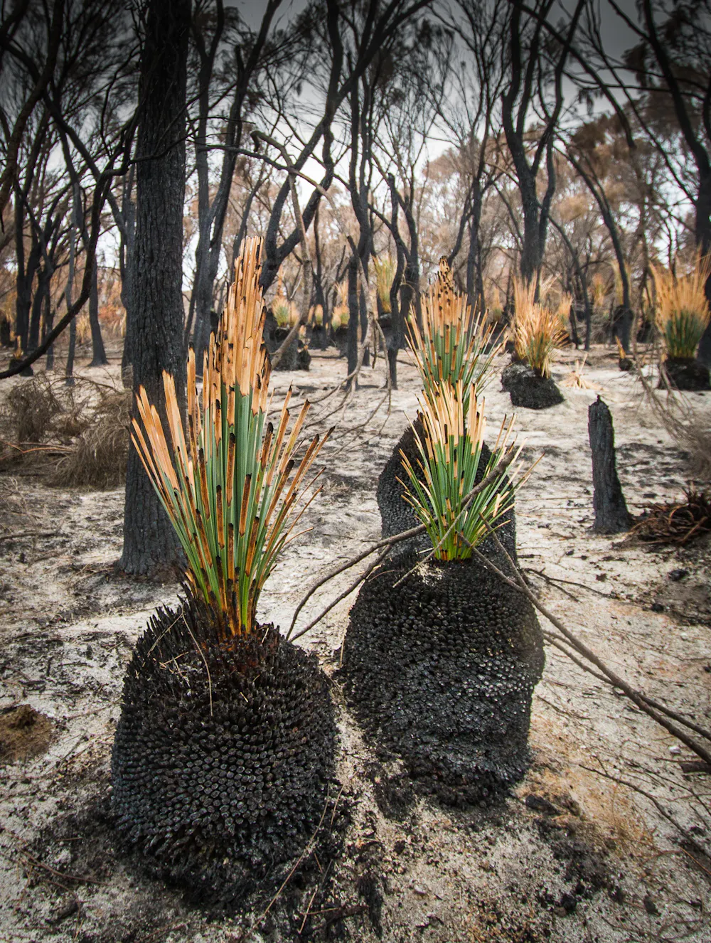 Grass trees are some of the first plants to regrow after a bushfire.
Wikimedia, CC BY
Grass trees are some of the first plants to regrow after a bushfire.
Wikimedia, CC BY
A few weeks later, I flew over fire-affected areas in the Adelaide Hills and had my first aerial view of the devastation. Fighting fires around my home, and what I saw on this flight, convinced me to get involved with helping recovery in the aftermath of the fires.
In the past year, I’ve taken high-resolution aerial data to monitor the recovery of fire-affected areas and help with post-fire efforts. This work includes clearing access tracks into burnt forests, locating unburnt areas within burnt forests to serve as refuges for wildlife, or simply documenting the degree of destruction.
I now have a unique dataset – a combination of very high-resolution and detail from three sensors: aerial photography, airborne Lidar (a way to measure distances with laser light) and hyperspectral imaging (looking at the landscape and vegetation with hundreds of narrow wavelengths).
Flying at just 250 metres above the ground, it’s possible to generate complete three-dimensional views and animations of the landscape and its features at resolutions in the 10cm-range.
Usually such airborne data is only available to government agencies, industry and sometimes researchers, but rarely to the general public. So we decided to make the data publicly available, so anyone can download it. It will help you appreciate the level of destruction, and how it varied for different landscapes.
My property, for example, is showing strong regrowth, but most of our neighbour’s block burnt so intensely that even now, after nearly one year, there’s very little regrowth even in terms of ground cover.
Here are a few examples of the landscape’s recovery around Kangaroo Island, generated from our data.
Bushfires decimated almost half of Kangaroo Island. The image sequence above shows a small area on Kangaroo Island before the fires and about one, three and nine months afterwards.
Before the fires, the landscape was dominated by dense bushland, which the fires nearly completely destroyed. The first signs of regrowth were visible after three months, and even more so after nine months.
The imagery is so detailed you can inspect the regrowth even for individual trees and scrubs. And in the slider below, you can more clearly compare how well the bushland regrew between February and October this year.
Much of Australia’s native flora have evolved to cope with fire. Grass trees are among the first species to recover, and the Lidar data below demonstrates just how dramatic this recovery is.
Thousands of grass trees (“yuccas”) on Kangaroo Island grew up to seven metre-high flowers in the months after the fires. This is a typical phenomenon for this species after fire, and we were lucky enough to see this first hand on our bushland property, too.
The video below shows the regrowth in and around a tree plantation on Kangaroo Island, directly after the fires and then after nine months. You can clearly see the intense regrowth on the ground and near the bottom of the burnt trees.
Usually firegrounds are observed via satellite imagery, imagery captured from high-flying survey aircraft and, more recently, using unmanned aerial vehicles (drones). None of these observations can map the landscape at the exceptionally high detail over large areas and with the combination of sensors as we have flown.
High-resolution aerial photographs at pixel sizes as small as five centimetres can be put together in a mosaic, covering many square kilometres. Combined with Lidar, and the hyperspectral scanner, we get detailed animations, such as those in the video, which can zero in on various intricate aspects, such as vegetation health.
With a some moderate funding, we can continue these regular mapping flights next year and beyond to learn how these areas develop. We can put this into context with other factors, such as burn severity, soil structure and vegetation type.
Such detailed datasets would assist researchers assessing flammability and fuel load (dried vegetation) which, in turn, would help prevent and even fight future fires.
Read more: Fire-ravaged Kangaroo Island is teeming with feral cats. It's bad news for this little marsupial
Flammability and fuel load, alongside the slope of the landscape, are key parameters in computer simulations of fire behaviour. High resolution datasets depicting landscapes before and after bushfire can verify the simulation results, and help to improve the performance of the models.
Our datasets can also be useful for people needing to access areas directly after the fires, such as identifying where burnt trees have fallen, or are just about to do so.
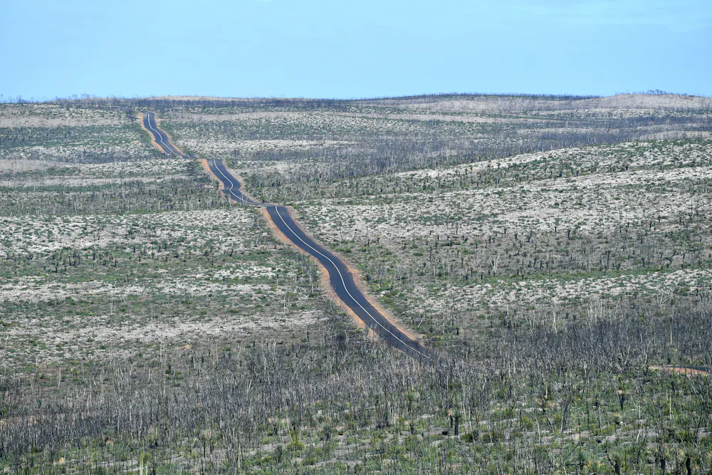 A view of regrowth on Kangaroo Island in June, 2020, from the Bunker Hill Lookout.
AAP Image/David Mariuz
A view of regrowth on Kangaroo Island in June, 2020, from the Bunker Hill Lookout.
AAP Image/David Mariuz
For our own bushland block in the Adelaide Hills, these detailed imagery and datasets means we can study the regrowth from the Cudlee Creek Fire almost a year ago, as well as from previous fires. For example, some areas were burnt in the 2015 Sampson Flat Fire and had already regrown over the four years — only to be burnt again.
Continuing such flights would require a comparatively low amount of funding. However, this is currently not available in the standard government grant system. You can download data from the mapping flights over Adelaide Hills and Kangaroo Island.
Read more: Yes, native plants can flourish after bushfire. But there’s only so much hardship they can take
Authors: Jorg Michael Hacker, Chief Scientist at Airborne Research Australia (ARA); and Professor, Flinders University