
How virtual 3D modelling and simulation can help us create better cities
- Written by: Yan Liu, Associate Professor, School of Earth and Environmental Sciences, The University of Queensland
New technologies offer new possibilities for planning and designing cities. 3D urban modelling and simulation can give a real sense of the outcomes of planning decisions. However, incorporating these technologies into planning practice has its challenges.
The possibilities of 3D modelling
A virtual 3D city model is a digital model of urban areas. It represents terrain surfaces, sites, buildings, vegetation, infrastructure and landscape elements, and other related objects belonging to an urban space.
This technique can be used to spatially design and visualise development in relation to the existing urban environment. It can also be used to compare different urban design strategies. These can be evaluated against measures such as land use, population and housing densities, building height, floor area ratio, and development costs.
Read more: Data visualisation isn't just for communication, it's also a research tool
Planners can use 3D modelling to analyse and communicate the impact of both existing and new (re)development plans. They can look, for example, at overshadowing, sunlight exposure, view corridors, compliance with zoning regulation, traffic gravity and solar potential of buildings – to name a few.
The 3D models also offer a new platform to involve citizens in urban planning. It is imperative that public concerns, needs and values are part of government decision-making.
How are cities using 3D models?
Local government and the private sector are increasingly using 3D city models to assist planning. An example is Virtual Brisbane. Brisbane City Council uses this computer-generated 3D model for strategic planning, development assessment and community engagement.
Singapore is launching Virtual Singapore, a 3D replica of the city-state in July 2018. This platform will offer new possibilities for urban planners.
Both Detroit in the US and Munich in Germany see realistic 3D modelling as important for planning their future.
Companies like Dassault Systems are partnering with different cities to use digital tools to develop more responsive cities. The 3DExperienceCity project allows urban planners to digitally test ideas and better consider the impact of urbanisation.
These techniques also integrate people, enabling a more personalised approach to planning to be developed.
Integration into planning education
The increasing demand from industry for spatially adept planners adds to the importance of introducing new ways of teaching and training built-environment professionals.
The University of Queensland is leading a project where researchers design and implement a sequential learning curriculum in its Bachelor of Urban and Town Planning program. By developing virtual 3D models students develop their spatial skills.
Students learn to use ESRI’s CityEngine, an industry-standard software to develop 3D city models. This enables them to visualise, plan, assess and communicate existing and new developments. Most students in our experiment were enthusiastic about this new learning opportunity to hone their spatial skills, particularly in the earlier stage of the learning process.
However, they were constrained by the limited time available to learn to use the technology. And the joy of learning and skill development is also challenged by the need to go beyond their comfort zone to secure a good grade in the course. Nonetheless, students became fully aware of the technologies and recognised the importance of spatial skills for their professional development.
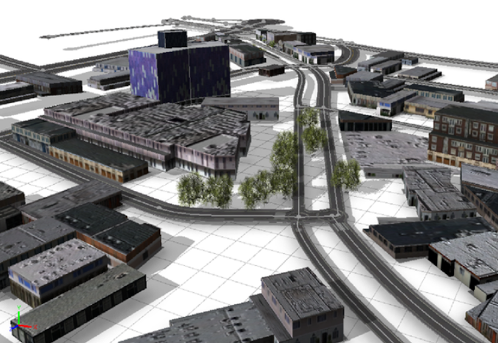 Example of students’ work using ESRI’s CityEngine program.
Author supplied
Example of students’ work using ESRI’s CityEngine program.
Author supplied
The emergence of geodesign is at the intersection of geography, urban design and geospatial technologies. It helps inform when, where and how students develop spatial thinking capacities and skills.
These capabilities are critical to managing, visualising, representing and navigating a data-based world. It also purposefully exposes students to innovative learning environments that allow them to visualise design scenarios and so better manage uncertainty.
The use of interactive digital mapping in higher education is an effective instructional strategy to teach and practise critical spatial thinking.
Augmented reality technology offers students a new way to visualise urban landscapes. It develops their map-reading skills and allows them to interpret landscape representations. This enhances their ability to understand the physical and digital aspects of urban places.
The rise of geospatial technologies, sensor networks and the “Internet of Things” is transforming the urban planning curriculum, design and pedagogy. It provides students with new ways of learning critical spatial thinking skills and improves the training of spatial planners to better equip them for the age of co-creation.
Read more: Internet of Things data will help us predict the future
It also improves their spatial literacy to co-design the built environment. This can help them become better planners, become more relevant to design practice and increase their overall competency and employability when they enter the workplace.
3D modelling and simulation certainly offer new possibilities in designing planning solutions. City dwellers must be included in this process to develop strategies that are more responsive to sustainability challenges such as urban population growth.
Authors: Yan Liu, Associate Professor, School of Earth and Environmental Sciences, The University of Queensland