
rivers were the highways of Australia's colonial history
- Written by: Imogen Wegman, Project officer, University of Tasmania
On November 2, 1816, Charles Repeat, “a poor old man”, was driving his master’s cart along the short route between Hobart and New Town in Van Diemen’s Land (Tasmania). He accidentally drove over a small tree stump, and was thrown from the cart and killed immediately.
By that time the British had been established in New Town for about 12 years, and this road was part of the route to several settlements further out of town. It was not an unused back street but a main road, and yet drivers still had to avoid the deadly perils of tree stumps.
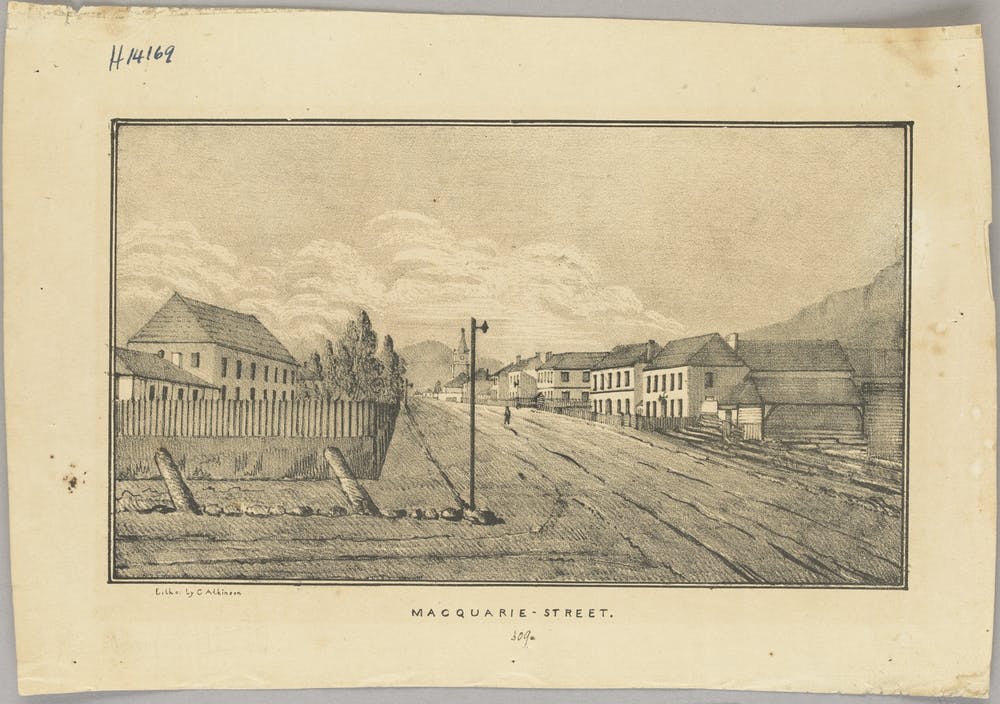 Even main roads could be in poor condition. Macquarie Street in Hobart, 1833.
State Library Victoria
Even main roads could be in poor condition. Macquarie Street in Hobart, 1833.
State Library Victoria
It was not that roads were not important – a network of overland routes was quickly spreading to connect the growing colony – but they were not the only transport routes. Waterways were also vital to transport systems, as overland routes were rough and slow. In Australia, rivers played a pivotal role in giving European settlers access to the land beyond the immediate coastlines, and shaped the modern cities we know today.
Charts of Van Diemen’s Land from expeditions by Abel Tasman, James Cook, and Nicolas Baudin reveal the extent to which these colonial explorers relied on rivers. The maps show water depths, fresh water supplies, and sources of timber for ship repairs. Mountain ranges are depicted as lines of peaks, as they would have appeared from the deck of a ship following the coastline. The world beyond navigable waterways was a place for speculation, not exploration.
Read more: New law finally gives voice to the Yarra River's traditional owners
Once the British arrived in Australia, one of their main concerns was finding sites for further expansion. Surveyors and adventurers recorded the landscape around the primary settlements, sometimes combining them together as in the case of one chart, described as “A map of all those parts of … New South Wales which have been seen by any person belonging to the settlement”. Other charts were surveyed and drafted by one person, such as James Meehan’s 1804 chart of the land alongside Hobart’s River Derwent.
 Chart showing exploration route along the Upper Derwent River, 1828.
Tasmanian Archives and Heritage Office
Chart showing exploration route along the Upper Derwent River, 1828.
Tasmanian Archives and Heritage Office
In Tasmania’s hilly landscape, valleys were often more accessible than the scrub-covered hills. Rivers also served as stable landmarks to identify important points in the environment, and were useful for retracing steps. Even some 30 years after the British were firmly settled in Tasmania, rivers remained the starting point for pushing out into areas they had not yet explored.
There were plenty more sensible reasons for concentrating on rivers, besides ease of access. They also provided the necessities of daily life: drinking water, irrigation for kitchen gardens, and a sewer for removing the less picturesque elements. This preoccupation with waterways is captured on charts showing the Tasmanian colony throughout the early 19th century, where all the settlements are based on the banks of rivers.
 Settlements around Hobart, based along the waterways.
Reconstructed by Imogen Wegman, original from Tasmanian Archives and Heritage Office
Settlements around Hobart, based along the waterways.
Reconstructed by Imogen Wegman, original from Tasmanian Archives and Heritage Office
Even places that could not be reached by river, such as Bothwell, 60km north of Hobart, needed fresh water. Settlements like New Norfolk, 20km from Hobart, were used as transport hubs between Bothwell and the colony’s governing centre. Goods could move between river and road along these routes, depending on the infrastructure, urgency and weather.
Individual properties could be focused on the rivers as well, with houses facing their front doors toward the main thoroughfare – the river. Tour guides at Woolmers Estate in northern Tasmania will tell you that the house was originally orientated towards the river. This was common among grand houses and small cottages alike. It was not until roads became more reliable that new properties began facing them instead.
The Archer family at Woolmers renovated and built a grand new entrance, now facing an overland access route. This was a power move, as it made sure that guests approaching the house would pass through the most impressive land, and their first sighting of the house would be the entrance. They would be duly awestruck by the grandeur (and therefore wealth) of their hosts.
Read more: A home for everyone? Property ownership has been about status and wealth since our convict days
The site of today’s Hobart central business district was chosen largely because of the waterways. The River Derwent was deep and suitable for ships, while the Hobart Rivulet (and others) provided fresh water for daily life and industry. Priorities change, however, and the rivulet has now been “all but obliterated from the city centre”, squashed into a series of culverts and tunnels.
The history of Australia’s colonial-era reliance on waterways will not be so easily buried, however. In May 2018, Hobart was hit by storms that brought 100mm of rain in a few hours. Hobart’s rivulets and streams broke their banks with spectacular vigour, washing over streets and into buildings. This was not the first time the Hobart Rivulet has brought the city to a standstill, and it will doubtless not be the last.
Floodwaters in Hobart, 10 May 2018 (ABC News)For those of us who live in today’s Australian cities, waterways can be easy to dismiss as simply picturesque places to paddle a kayak or have a swim. But historically they were so much more. In fact, without rivers, the people who sowed the seeds of our modern cities would not have got very far at all.
Authors: Imogen Wegman, Project officer, University of Tasmania