Choosing the Right LiDAR System for Your Project
When planning a project that relies on accurate spatial data, selecting the right LiDAR system is one of the most critical decisions you’ll make. From environmental studies and mining operations to infrastructure development and urban planning, LiDAR technology provides precise 3D mapping that supports informed decision-making. With a variety of systems available on the market, the challenge lies in choosing the right solution for your specific application. Partnering with experienced providers such as LiDAR Solutions can ensure you get the best fit for your needs.
Understanding Different Types of LiDAR Systems
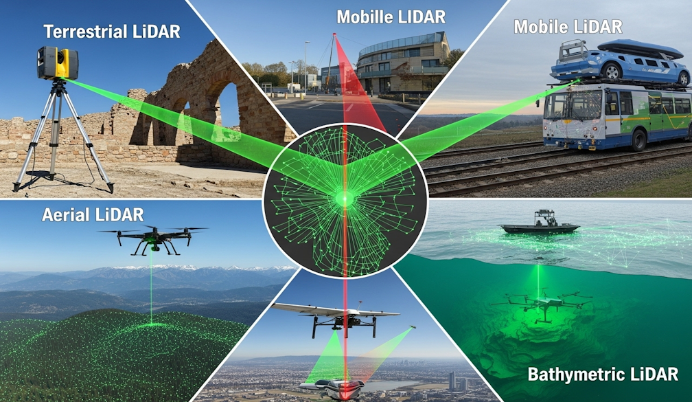
LiDAR (Light Detection and Ranging) comes in several formats, each suited to different project requirements:
- Terrestrial LiDAR: Ground-based systems ideal for capturing detailed scans of structures, landscapes, and vegetation. Commonly used in construction, archaeology, and forestry.
- Mobile LiDAR: Mounted on vehicles, this system collects data quickly across transport networks, making it highly effective for road surveys, railways, and urban streetscapes.
- Aerial LiDAR: Deployed via aircraft or drones, aerial systems can map large areas with speed and precision. They are invaluable for flood modelling, topographic surveys, and environmental monitoring.
- Bathymetric LiDAR: Specialised for coastal and river environments, this system uses green laser technology to penetrate water, allowing accurate mapping of underwater terrain.
Key Considerations When Choosing a System
The right LiDAR system depends on your project’s scale, terrain, and required level of detail. Some important factors to weigh include:
- Project Size and Area Coverage: For large areas, aerial LiDAR offers speed and broad coverage, while terrestrial systems are better suited for smaller, detailed sites.
- Data Accuracy: High-precision projects, such as infrastructure or asset management, demand systems capable of millimetre-level accuracy.
- Environmental Conditions: Terrain, vegetation density, and water presence can influence the system type. Bathymetric LiDAR, for example, is essential where waterways are involved.
- Budget and Resources: Cost varies depending on the technology, data volume, and processing requirements. Balancing accuracy with affordability is crucial.
Matching LiDAR Technology to Industry Needs
Every industry applies LiDAR differently. Mining companies often rely on mobile and aerial LiDAR for volumetric analysis and safety assessments. Environmental agencies may favour aerial and bathymetric systems for habitat monitoring, while local councils and developers frequently use terrestrial LiDAR for site planning and infrastructure projects. Understanding the context in which you’ll apply the data is key to ensuring the system you select adds genuine value.
Why Expert Guidance Matters
While it’s tempting to focus on specifications alone, consulting with industry specialists can save time and reduce costs in the long run. Experts help interpret technical requirements, recommend the right system, and ensure your project benefits from efficient data capture and processing workflows.
Final Thoughts
Selecting the right LiDAR system is about more than technology—it’s about aligning the tool with your project’s goals, environment, and budget. By carefully considering your needs and seeking professional advice, you’ll be better positioned to harness the full potential of LiDAR for accurate and reliable outcomes.